Learning activities previews knowledge: Interactive Map Exploration (1hour) Objective: To visually introduce students to the colonial division of Africa. Instructions: https://docs.google.com/document/d/187aXNv_HUO85Y7KL0P_QgTDYK0Wf3-4uMOhmfab7XoY/edit?usp=sharing 1. Color-code a blank map of Africa based on colonial powers. 2. In a second Africa map Identify and mark current countries. Discuss with a friend: How did colonial borders disregard ethnic and cultural boundaries? What conflicts today can be traced back to these colonial divisions?
º COMPETITION! Get together with a friend and observe this cartoon-style images of a happy African family having a picnic. Find the five differences in 20 seconds. Are you ready?
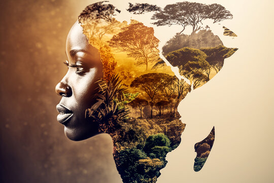
𝒞𝒪𝐿𝒪𝒩𝐼𝒜𝐿 𝐸𝑀𝒫𝐼𝑅𝐸𝒮 𝐼𝒩 𝒜𝐹𝑅𝐼𝒞𝒜
Our first stop is Africa, where the scramble for territory reshaped the continent’s destiny. Through maps and narratives, we’ll uncover the effects of European division and control, seeking to understand the profound changes brought upon African societies. Hochschild, Adam. “King Leopold’s Ghost: A Story of Greed, Terror, and Heroism in Colonial Africa.” Houghton Mifflin Harcourt, 1998.
You can see a video of the wonderful country of Capetown in 3D here just click the link below:
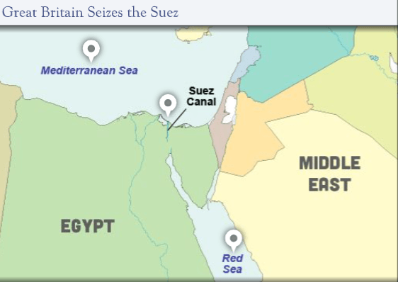
Between 1750 and 1900, European empires rapidly expanded into foreign territories. Sometimes called the long 19th century, this was a time when existing empires expanded their borders and new empires rose to compete. By the end of the 19th century, every major European country had colonies outside Europe. SUEZ CANAL *Great Britain’s Lifeline to India The Suez Canal, in the African nation of Egypt, made it possible for European ships to easily reach India and the Far East. Without easy access to this route, ships would have had to travel around Africa to bring goods from India and Asia. This was especially important to Great Britain, which controlled most of India and exported a great deal of natural resources from the country. In 1882, British forces defeated the Egyptian army and formally took control of the country in order to regulate the Suez Canal for Great Britain’s benefit. Once the British controlled Egypt and the canal, other European countries took notice and joined the scramble for Africa.
Observe the map below and analize.
Analize the map and the text then answer this question and share with your companions: (30min) What other regions besides India does the Suez Canal give European ships access to? What other ways did the British have of reaching their colonies in India?
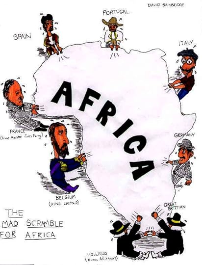
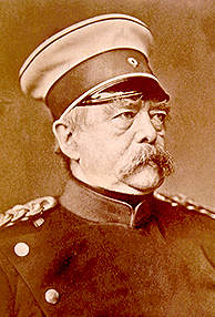
In 1884, German chancellor Otto von Bismarck called the Berlin Conference. They where 14 imperial powers met to discuss how Africa could be divided peacefully among them.
As a result of the conference, European powers established rules for which nations could occupy territory in Africa. They also defined territorial boundaries and agreed to keep several major rivers open for shipping and trade
The explotation, especially by Belgium, was often brutal and added to the misery already inflicted on Africa from the Atlantic slave trade.
European Powers Divide Territory in Africa After the conference, Belgium established a colony in the Congo
while Germany took over East Africa. Within 25 years, Europeans had claimed most of Africa, and they began exploiting their new possessions
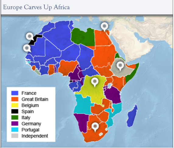
Observe the map below, and match the name of Colonies with the correct color in the Political Africa map.
Barinstoirm: Why do you think Spain claimed such a small part of Africa? (30min)
Let’s see if you know a lot!
Reviewing the Results of the Scramble for Africa
By 1900, nearly all of Africa was controlled by imperial powers. Take a moment to check your understanding of the results of the scramble for Africa: (20min)
Which territory in Africa was controlled by the Belgian king Leopold II?
A.Algeria
B.The Congo
C.Ethiopia
Which territory in Africa kept its independence by defeating Italy?
A.Ethiopia
B.Liberia
C.The Congo
Which nation practiced a system of indirect rule in its African colonies?
A.France
B.Germany
Colonial Empires in India
Forum Description
Colonialism in Africa
Learning activities previews knowledge: Interactive Map Exploration (1hour) Objective: To visually introduce students to the colonial division of Africa. Instructions: https://docs.google.com/document/d/187aXNv_HUO85Y7KL0P_QgTDYK0Wf3-4uMOhmfab7XoY/edit?usp=sharing 1. Color-code a blank map of Africa based on colonial powers. 2. In a second Africa map Identify and mark current countries. Discuss with a friend: How did colonial borders disregard ethnic and cultural boundaries? What conflicts today can be traced back to these colonial divisions?
º COMPETITION! Get together with a friend and observe this cartoon-style images of a happy African family having a picnic. Find the five differences in 20 seconds. Are you ready?
𝒞𝒪𝐿𝒪𝒩𝐼𝒜𝐿 𝐸𝑀𝒫𝐼𝑅𝐸𝒮 𝐼𝒩 𝒜𝐹𝑅𝐼𝒞𝒜
Our first stop is Africa, where the scramble for territory reshaped the continent's destiny. Through maps and narratives, we'll uncover the effects of European division and control, seeking to understand the profound changes brought upon African societies. Hochschild, Adam. "King Leopold's Ghost: A Story of Greed, Terror, and Heroism in Colonial Africa." Houghton Mifflin Harcourt, 1998.
You can see a video of the wonderful country of Capetown in 3D here just click the link below:
Between 1750 and 1900, European empires rapidly expanded into foreign territories. Sometimes called the long 19th century, this was a time when existing empires expanded their borders and new empires rose to compete. By the end of the 19th century, every major European country had colonies outside Europe. SUEZ CANAL *Great Britain's Lifeline to India The Suez Canal, in the African nation of Egypt, made it possible for European ships to easily reach India and the Far East. Without easy access to this route, ships would have had to travel around Africa to bring goods from India and Asia. This was especially important to Great Britain, which controlled most of India and exported a great deal of natural resources from the country. In 1882, British forces defeated the Egyptian army and formally took control of the country in order to regulate the Suez Canal for Great Britain's benefit. Once the British controlled Egypt and the canal, other European countries took notice and joined the scramble for Africa.
Observe the map below and analize.
Analize the map and the text then answer this question and share with your companions: (30min) What other regions besides India does the Suez Canal give European ships access to? What other ways did the British have of reaching their colonies in India?
In 1884, German chancellor Otto von Bismarck called the Berlin Conference. They where 14 imperial powers met to discuss how Africa could be divided peacefully among them.
As a result of the conference, European powers established rules for which nations could occupy territory in Africa. They also defined territorial boundaries and agreed to keep several major rivers open for shipping and trade
The explotation, especially by Belgium, was often brutal and added to the misery already inflicted on Africa from the Atlantic slave trade.
European Powers Divide Territory in Africa After the conference, Belgium established a colony in the Congo
while Germany took over East Africa. Within 25 years, Europeans had claimed most of Africa, and they began exploiting their new possessions
Observe the map below, and match the name of Colonies with the correct color in the Political Africa map.
Barinstoirm: Why do you think Spain claimed such a small part of Africa? (30min)
Let's see if you know a lot!
Reviewing the Results of the Scramble for Africa
By 1900, nearly all of Africa was controlled by imperial powers. Take a moment to check your understanding of the results of the scramble for Africa: (20min)
Which territory in Africa was controlled by the Belgian king Leopold II?
A.Algeria
B.The Congo
C.Ethiopia
Which territory in Africa kept its independence by defeating Italy?
A.Ethiopia
B.Liberia
C.The Congo
Which nation practiced a system of indirect rule in its African colonies?
A.France
B.Germany
https://www.youtube.com/watch?v=Rq8XU4gj-Gg
Colonial Empires in India
Report
There was a problem reporting this post.
Block Member?
Please confirm you want to block this member.
You will no longer be able to:
See blocked member's posts
Mention this member in posts
Invite this member to groups
Message this member
Add this member as a connection
Please note:
This action will also remove this member from your connections and send a report to the site admin.
Please allow a few minutes for this process to complete.